SketchUp is a powerful rendering tool which offers an intuitive interface, perfect for urban planners and designers, enabling them to create visually stunning and accurate representations of their ideas. Today, you’ll explore urban planning rendering in SketchUp, with a selection of recommended plugins to use.
Understanding the Importance of Urban Planning Rendering in SketchUp
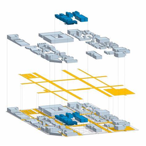
SketchUp brings robust rendering capabilities for quick visualisation and an extensive library of pre-built components for a fast design process. Urban planning rendering in SketchUp introduces realism and improves visualisation and communication with investors, stakeholders and the community.
Using SketchUp for urban planning allows you to create detailed 3D models of buildings, streets, and parks. For example, this software was used for rendering the High Line Park in New York and the South Boston Waterfront District and has been instrumental in conveying the urban context and proposed design to the public and investors alike.
Essential Tips for Urban Planning Rendering in SketchUp
SketchUp brings you a selection of native tools and plugins for urban planning rendering, such as:
- Material Editor
- Lighting tools
- Section Planes
- SketchUp’s 3D Warehouse
- V-Ray
- Lumion 3D
- Enscape
- Skatter
- Instant Terrain
- Eneroth
- TurboSquid
- Instant Road
- RenderHub
Apply Materials with the Paint Bucket tool, or swap one material for another via Ctrl, Shift, or Ctrl+Shift (Windows) or Option, Shift, Option+Shift (Mac). You can also easily change the structure of the Material because the colour and texture are separated. Explore roof or wall materials and follow other tutorials for more options.
If you wish to use Lighting tools, install Enscape to combine it with SketchUp. Then you can adjust the sun in the Enscape rendering window, or visit the Enscape Objects button to find Sphere, Spot, Linear, Rectangular, and Disk lighting types to redesign the appearance of your light source.
Once you finish your design, use the Slicing a Model feature to look at how your models are organised. Select the Section Plane tool or go to Tools – Section plane, adjust the placement with the Move tool, align the camera, and determine which section is the active cut.
Additionally, explore SketchUp’s 3D Warehouse and its selection of 5 million models and products to pick whatever you need for urban rendering.
The V-Ray plugin is known for its ability to create highly realistic renderings with advanced lighting, materials, textures, global illumination, and more. It’s flexible, and professional, yet has some learning curve.
You also have Lumion 3D and Enscape, more real-time rendering extensions, that seamlessly integrate with SketchUp and come with a material library, objects, and environmental effects.
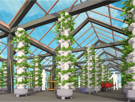
If you want to include some natural elements and vegetation, there’s Skatter, a plugin that facilitates the distribution of objects (trees, plants, and people) across surfaces. Instant Terrain and Eneroth will help you manage terrain, while SketchUp has an import GIS feature which enables the integration of real-world geographic data.
Finally, you’ll find that TurboSquid, Instant Road, and RenderHub offer pre-built urban components (roads and buildings) which save time during the modelling process.
Recommended Extensions for Urban Planning Rendering in SketchUp
Urban planning rendering in SketchUp is easy with these extensions:
- V-Ray for SketchUp – combines real-time and photorealistic rendering
- Enscape – offers rendering and virtual reality features, lighting simulations, and environmental effects
- Lumion – known for its speed, details, and atmosphere features
- Artisan – brings subdivision, sculpting, soft selection, and free-form deformation options to improve design
All these plugins can easily be integrated with SketchUp to provide advanced rendering options and elevate your workflow. Then, there are plugins which bring additional urban planning features, such as building massing tools, traffic simulation, or urban analysis:
- Profile Builder – ideal for quick modelling of smart building materials
- PlaceMaker – gives you access to high-resolution aerials, terrain, and 3D cities
- Skalp – offers Pattern textures, live updates, mapping queries, Styles, and more
- Urban Network Analysis – computes five types of graph analysis measures on spatial networks
With these extensions, you can evaluate design alternatives, track development, and assess the visual impact of your projects. SketchUp for urban planning integrates with other rendering software and GIS platforms, which helps you manage data exchange or accurately run urban simulations.
Elevating Urban Planning Rendering in SketchUp
Urban planning rendering in SketchUp facilitates effective communication, stakeholder engagement, and informed decision-making in urban planning projects.
Using realistic materials and lighting together with post-processing techniques guarantees impactful renders. With SketchUp for urban planning, you’ll have access to intuitive tools and streamlined workflow.
Combine the power of SketchUp with Artisan, V-Ray, or Lumion for lifelike renders, or utilise Urban Network Analysis or Place Maker plugins for analysing terrain and implementing 3D cities. Visit Elmtec today to explore free trial options and purchasing options.