Capturing a 3D city model is an inherently complex project. Who is the final user of the 3D city model? How is the model going to be used and updated? What is the most suitable source data, available technology to capture, display and exploit the data, what are the expected production times, costs and investment returns? There are hundreds of crucial decisions on variables like these that can greatly alter the scope, usability and cost of the project. Over the last 3 years AccuCities have worked with over 180 customers on 1,400 small and medium-size 3D context models for sites all over the United Kingdom. We spoke with Milo Spisz and Brais Brenlla Ramos to find out how SketchUp helps them with all of the above!

Tell us about your background and talk us through what AccuCities does
Milo: Howdy! I am Milo, the 3D Modelling Lead at AccuCities. I have been in this industry for the past 6 years, and spent the majority of my degree working with SketchUp.
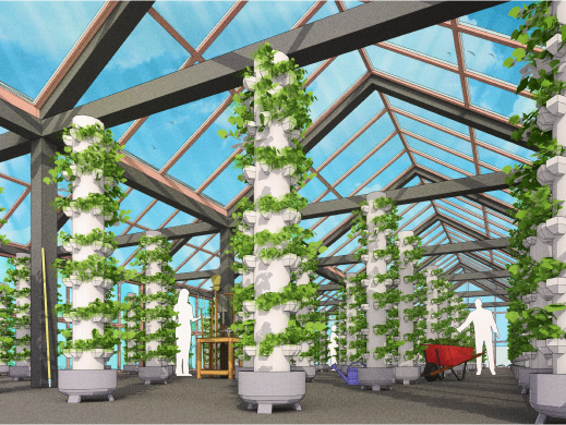
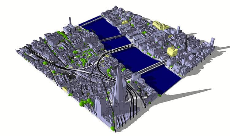
Brais: Hi I am Brais, the Lead UE4 Developer. Accucities specialises in highly accurate 3D modelling of cities primarily in the UK from the use of advanced remote sensing technology in order to obtain high detail imagery. Our models are used by clients in a wide variety of fields such as architecture, gaming and film industries. We focus on the built environment – cities, neighbourhoods, development sites and other key areas. The end results we can produce benefit from that same degree of accuracy and end up serving a multitude of purposes. These range from helping construction companies visualise the built environment, or letting consultancies run precise analyses of their area of study. Furthermore, we also put our products together in an interactive app to let our users play around with the model and explore multiple different tools – from data overlays to real-time tools, all with the goal of empowering our clients.
What do you love most about your job and the industry you work in?
Milo: It would have to be the idea of scale, speed and accuracy that we can produce our models, how we put it together, how everything fits so well and looks the way it should be. It’s also great to see how we can help our clients by providing them with our data. I would also say we are one of those small gears in the process that helps to build and improve the cities we live in.
Brais: This job is a great opportunity to stay up to date with the latest trends in technology, so I’d say that’s one of the things I love the most. Staying fresh in this industry also means learning something new every day, as each new technology that appears on the horizon brings benefits and challenges that we must tackle. The industry itself is great because of that – the thrill of learning something new every day, and the fulfilment that comes after achieving goals that were just impossible a bit further back.
What are your favourite kinds of projects to work on?
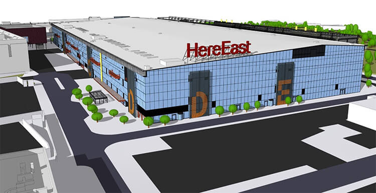
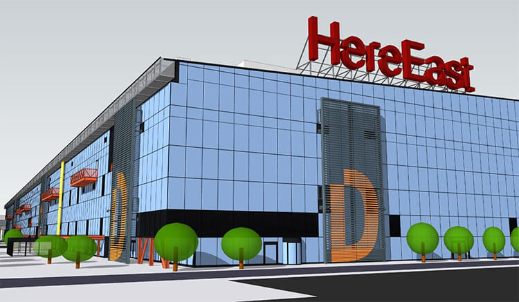
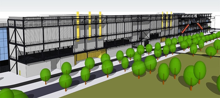
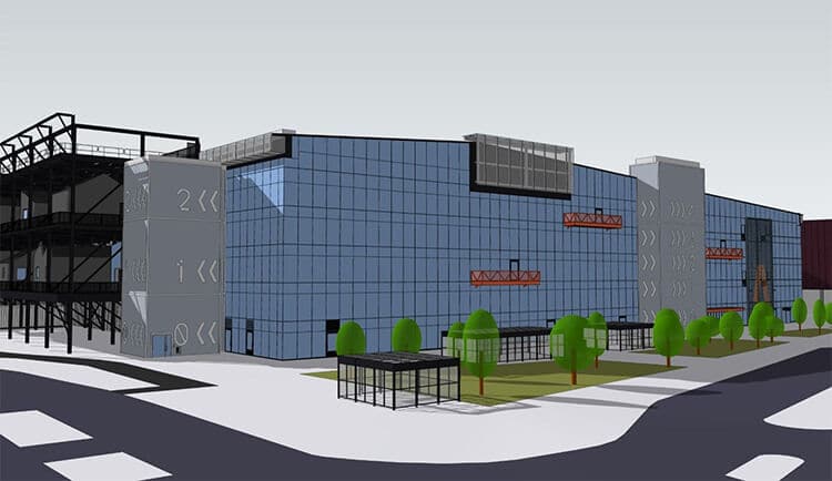
Milo: The favourite projects I love the most are high detail models that we produce which we call Level 4 such as Here East model as well as working on the future proposed developments of buildings – with these you get a small glimpse of what is to come in the city. Our Level 4 models share the same high accuracy as our standard Level 3 but they are much richer in detail on the facades, working on these details can be very therapeutic for me because it takes a keen eye to make sure all the details are in the right place, size and proportion.
Brais: Those would need to be the ones that challenge me by just the right amount – neither too daunting nor overly simplistic. It’s easy for a tech company to either fall into routine work or face insurmountable tasks, and while that is something that inevitably happens every now and then, projects that strike just the right balance have an easy time to outshine the others.
How does SketchUp fit into your workflow?
Milo: We use SketchUp to deliver the final model to our clients. Many of our clients work with SketchUp already and we provide them with our data in SKP format which enables them to use the model to further aid on their design/environmental analysis.
Talk us through the Here East project!
Milo: Here East Level 4 was a fun model to work with! So, it all starts with the references of the building – part of my job is to source all the reference material such as plans and photos of the model so that we can ensure the accuracy is on point. We then use our Level 3 high detail model which helps us initially with positioning and the proportions of the details. Then the fun part starts which is all the detail – This obviously is time consuming but with experience it becomes easier and you can plan the entire model in such a way where you can save time without sacrificing quality.
As a company your focus is on cities – London, in particular. What are the future challenges involved for the built environment for a city like London?
Brais: London is always under construction and evolving, there is always a new development happening, where a building is being demolished and that area is being used for a new building or landscape area for the city. So, the challenge would be to keep up with these changes and we at Accucities are always updating our data to make sure our clients can get the most up to date model of London.
In regards to working on cities, the client’s requests can be for scientific research and so we need to take into consideration what the end user is and what type of data the end user will need to gather from our 3D Models. This is ever so in demand due to the environmental concerns and sustainability with increased demand of space. More clients are needing 3d Models to gather science research to deploy better methods on construction or refurb on both existing and proposed buildings within the city.
Any must have SketchUp extensions that make your life easier?
Milo: Our native London model is always geo-referenced so it’s located within the National Grid which is a universal standard within the UK for us and our clients. However, this can sometimes be problematic because the model can live very far from the 0,0,0 coordinate and this can cause some issues within some software. To solve this, we use an extension within SketchUp that “zero’s” the axis back to the model and prevents any issues with the geometries that might otherwise happen.To learn more about Accucities, visit their website.
To download a sample tile. Link: https://www.accucities.com/new-3d-london-samples-cover-full-square-kilometer/